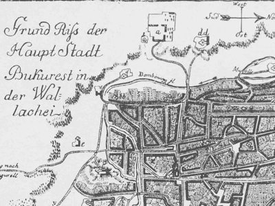
The first plan of the city was produced in 1780 by Franz Josef Sulzer in his work ‘Geschichte des Transalpinischen Daciens, das ist der Walachey, Moldau und Bessarabiens’. While it contains many imprecise details and several errors, as well as lacking certain routes, it provides a good image of the way the city developed at that point, which was a major one for Bucharest. A far more accurate and detailed city plan was to be drawn by Austrian origin, Russian Major Rudolf Artur Borroczyn in 1847. If in the 16th and 17th century the town was not too large, the 18th century saw the urge to organize it in districts. A 1798 research saw the city divided in 5 districts (Ro. plase): the Târgul din Năuntru (En. the town proper including the fortress, roughly the area between the actual Piața Unirii and Regina Elisabeta Avenue, respectively Calea Victoriei and Nicolae Bălcescu Avenue), the Gorgani (W of Calea Victoriei), the Broșteni (S of Calea Moșilor), the Târgul de Afară (En. the outer town, centered by the actual Obor Market) and the Podul Mogoșoaei (E of Calea Victoriei). These districts had smaller divisions, the ‘mahalas’, usually organized around a church or monastery, as the church had a good share of the land and was very wealthy at the time. Friedrich Wilhelm von Bauer mentions 67 mahalas in the 5 districts of Bucharest in his work ‘Memoires historiques et geographiques sur la Valachie’ (1778); their number and names would change as the city developed. A mahala consisted of up to 335 houses, but usually lay in the 20-100 house area. Poorer mahalas had the houses built of clay, half lying under the ground and only 1-2 feet above it, so that weeds overgrew them in summer. Once a mahala developed and basic infrastructure emerged (i.e. a street network), the church centering it started asking for a tax from the dwellers, as it owned the land.
Many streets had no name and only the great fire in 1804 (when a major part of the Târg, of the town proper, burnt down) had the ruler of the time, Constantin Ipsilanti, set rules for those building new houses. Houses needed be built in a straight line, along a precise street lane. In many mahalas there used to exist a main street which was called the Ulița Mare (the Great Street), while the other streets were actually narrow lanes that emerged into the former. Streets that had names (as many did not have one) bore those of the merchants, landlords or craftsmen that lived along them. Before the 18th century, the main streets were paved with wood beams and planks. Stumps and beams stuck in the ground were meant to fix the typically muddy terrain the town had been set on, and they granted the name of several streets such as the Podul Mogoșoaiei (En. Mogoșoaia Bridge, the original name of Calea Victoriei). Mahala dwellers were supposed to maintain the good state of this ‘pavement’ along their main streets, while larger monasteries were in charge of the streets leading to their quarters. Under the rule of Grigore-Vodă Ghika, the first cobblestone paved streets appeared in 1824.
At that time there were 5 major roads across town, as it follows: Calea or Podul Mogoșoaiei (North of River Dâmbovița, making the junction between the town court and the summer residence of the ruler, in Mogoșoaia Village), Calea Șerban Vodă also known as Podul Beilicului (South of the town proper), Calea Moșilor also known as Podul Târgului din Afară (East of the town proper, leading to the Obor market), Calea Craiovei (South-West of the town proper, also known as Podul Calicilor and currently called Calea Rahovei) and the Podul de Pământ (West of the town proper and the only one that was not paved with wood, currently known as Calea Plevnei). The same time frame saw 13 gates allowing access into town to a great number of peasants coming to sell their produce and to just as many merchants, as the city lay on the busy road coming from Istanbul towards Central and Western Europe.
The city was to see a major change starting with the end of the 19th century, when wide, tree-lined avenues were drawn across the former maze of narrow streets; a North - South avenue was created in parallel with the Calea Victoriei, while the Northern part of the city would see a geometrical pattern development. While these changes came together with new imposing buildings, the plethora of narrow, winding streets bordered by fine, relaxed properties continued to exist and develop at their own pace, whether they were meant for merchants and customers, rich landlords, industrialists, artists or the many anonymous. Some of these districts with their houses and history are the ones I am going to write about in this section of the website. This is just a selection and the districts here do not necessarily follow the old divisions precisely, but rather today’s opportunism for an interesting and relaxed walk.